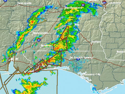

CRESTVIEW — The National Weather Service reports a strong weather cell is approaching the area from the west, including tornado watches. At 9:46, the tornado watch area had passed over northern Okaloosa County into Walton County and southern Alabama, but further tornado watches were approaching from the west.
After the band of squalls passed through, local weather spotter Chayne Sparagowski reported the storm activity has "weakened some." Sparagowski operates a Crestview-based weather station that contributes to the National Weather Service.
Sparagowski reported "lots of rotation but nothing strong," indicating that while the storm system had the possibility of forming tornadoes, conditions were not suitable to generate a twister.
Both the National Weather Service and Sparagowski said further wind and rain can be expected throughout the morning.
"There's more to come, but things overall are tending to weaken," Sparagowski said.
This article originally appeared on Crestview News Bulletin: 'Strong' weather cell passing through