
BAKER — More than a dozen road closures, most in north Okaloosa County, as well as several more in Walton County, occurred earlier this week as Hurricane Isaac took one more swipe at the region, this time from much farther north.
While the Emerald Coast dodged a direct strike from the storm as it headed into Louisiana, the area experienced several inches of rain in some parts of the north county. As the sun peeped out earlier this week, however, Isaac made himself felt again when heavy rains dumped water in the central part of the United States that sent crests down local estuaries.
Randy McDaniel, chief of emergency management for Okaloosa County, said while the Crestview area was not affected, communities north of Baker along the Blackwater River suffered some flooding and road closures.
County public information officer Kathy Newby announced 13 road closures Wednesday afternoon, 12 of them along Blackwater River. The 13th closure, Old Dorcas Road in the Dorcas community east of Crestview, was affected by a crest riding down the Shoal River, and with three roads near Baker, remained closed Thursday morning.
“The Shoal River at Highway 90 is currently at 16.1 feet, and it appears it has crested,” McDaniel reported Wednesday. “It should start dropping very soon.”
Thursday morning, county Public Works crews patrolled the previously closed roads, checking the depth of estuaries crossed by local roads and reopening most of the roads closed the previous day.
“The Blackwater is rising,” McDaniel said Wednesday. “It is currently at 16.4 feet. It is at moderate flood stage. At that level, we have some homes that could be threatened. We have notified the residents through the Code Red system, but the river has caused flooding on the roadways.”
According to the National Weather Service website, the river ultimately reached 17.02 feet, more than a foot above the moderate flood stage. By Thursday morning, however, it had dropped to 11.5 feet and was predicted to keep falling.
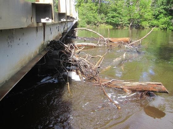
Peaden Bridge, east of the Beaver Creek community, reopened Thursday morning, though the water was barely a foot below the bridge supports. The fast current pushed debris against the bridge structure, and water flooded the forested banks lining the river.
While Yellow River, at 8.84 feet, was higher than normal as it crossed U.S. Highway 90, it did not pose a significant threat, McDaniel said. Flood stage for the river is 12 feet, according to the weather service.
“The Yellow River is behaving very well,” he said. “It’s supposed to crest at 7.9 feet, which is below flood stage.”
As the flood waters receded, McDaniel said his department was already eying the next suspicious storm system developing in the southern Gulf of Mexico, which is being monitored by the National Hurricane Center in Miami.
“The low pressure has moved out into the gulf and has been assigned a number,” McDaniel said. “That means they’re watching it for tropic development. Currently, according to the NHC, it has a 43 percent chance of turning into a tropical cyclone.
“If that happens, the current models have it running toward the Big Bend and main peninsula of Florida, although they show drifting southwest and heading back to the East.”
This article originally appeared on Crestview News Bulletin: Isaac takes one last swipe with local flooding