
CRESTVIEW — Locals know if they want a good meal, head to Mrs. Kolonowski's old house. For a fresh field-picked watermelon, swing by the farm stand on Blueberry Curve. Need some fast food? There's plenty on Juke Hill.
Native and long-time residents' penchant for identifying locations and giving directions using traditional place names and landmarks rather than street addresses often confuses newcomers.
After all, how does one plug "Chicken Head" into a GPS?
Here's a guide to help newcomers fit into their new hometown. Soon, "driving through The Quarters" will come easily.
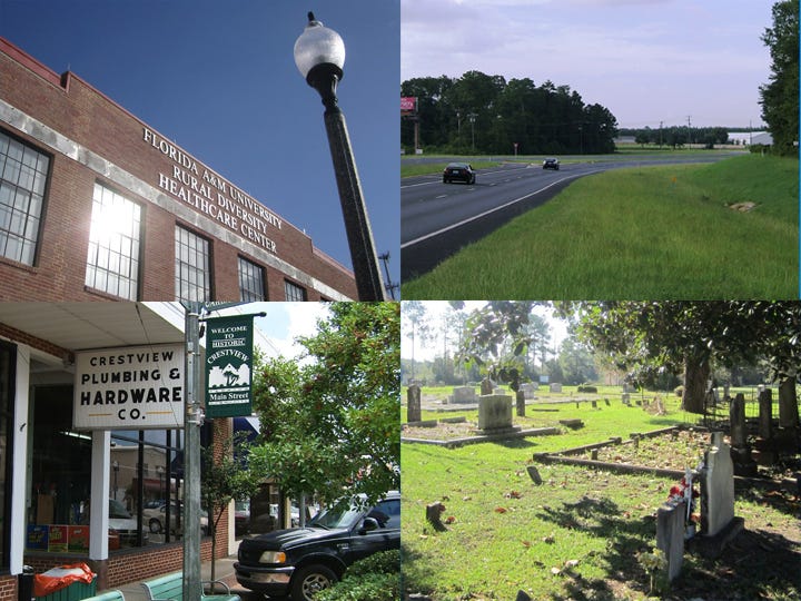
ALATEX BUILDING: The classic American brick industrial building on Woodruff Avenue is now the home of Florida A&M University's Rural Diversity Healthcare Center.
Locals also fondly remember it as "the sewing factory" that provided jobs for many workers during the Depression. It also used to house City Hall.
ALMIRANTE: One of the county's first communities, located near present-day Laurel Hill, is still remembered through institutions such as the Almarante Fire District and Almarante Cemetery.
NOTE: Spelling difference between community name and fire, cemetery name
BACK STREET: In the 1920s, Fourth Street in Laurel Hill was a main thoroughfare, lined with some of the railroad town's nicest residences, Laurel Hill School and the then-bustling Presbyterian Church. So Third Street, the less prominent street behind it, was the "back street."
BLUEBERRY CURVE: The sweeping right curve on State Road 85 north of Winn-Dixie was named for the area's abundant blueberry crops in the 1930s. It was seen briefly in the locally-shot Gregory Peck World War II film, "Twelve O'Clock High."
CHICKEN HEAD: This is the big left curve on SR 85 approaching the straight-away by Farm and Garden World south of Laurel Hill. Chicken poachers would go down the embankment to behead their ill-gotten pullets.
HOG-N-HOMINY ROAD: County Highway 2 between Blackman and Laurel Hill was nicknamed by 1940s radio personality Cooter Douglas in a good-natured poke at the north county's agrarian lifestyle.
JUKE HILL: The stretch of SR 85 between the north and south entrances to West Redstone Avenue, containing Walgreens, Krystal, Dunkin Donuts, Captain D's and other businesses formerly contained several colorful juke joints.
Legend has it that certain commercial sites on the hill were jinxed and doomed to failure, but today's businesses seem to have broken the jinx.
MAR-CAMP: The longtime watering hole west of town on U.S. Highway 90 was originally a family-friendly recreation place, but later gained infamy as such a rowdy watering hole, the sheriff's office had a dedicated phone number to report troubles at the establishment.
It later became Keye’s Lounge, but its reputation remained intact. Now it's a mattress store.
MRS. KOLANOWSKI'S HOUSE: Today's Wild Olive Restaurant is in Mrs. Rosalyn Kolanowski's old home on the corner of Pearl Street and Hickory Avenue.
OWC: Okaloosa-Walton Junior College’s name was changed to Northwest Florida State College in July 2008, but long-time locals will always call it OWC, or just OW.
THE QUARTERS: The residential neighborhood of Laurel Hill on Old Ebenezer Road west of Gene Clary Park. The woods north and west of The Quarters were where "the squirrels were cooking supper," an old foresters' euphemism for telltale smoke from moonshine operations.
RADIO VALLEY: On south State Road 85, right before P.J. Adams Parkway, was the broadcasting tower for WCNU, Crestview's first radio station that signed on in 1948.
Sam Townsend, who ran the station, had his home near there. The station's studio was in a store across Main Street from present-day Desi's Restaurant.
SHOFFNER CITY: One of the area's first post-World War II planned neighborhoods was developed by Col. Arthur Shoffner, a real estate pioneer who established several area subdivisions.
The neighborhood south of Bob Sikes Airport still has several of its original one-story cement-block homes. Shoffner Boulevard, a two-story lane, named for the development's founder, is the preferred southern route to the airport over Hare Street, the dirt "official" access road.
THE SUPERETTE: Long-time locals will always memorialize a long-gone grocery store, the present-day Ritz convenience store at the Chevron station in Baker, by using its original name.
TED STEELE'S HARDWARE: Ted sold Crestview Plumbing and Hardware on Main Street to his nephew, Pete, who sold it to its present owners and then worked there for awhile.
TOMMY HORN'S: Crestview Nurseries on Houston Lane was owned by Tommy Horn, but now his children, Dan, BeBe and Dusty, run it.
Their variety of seasonally appropriate plants and flowers is renowned, drawing customers from as far away as Alabama and Fort Walton Beach, which older locals still call "Camp Walton," its name until the city promoted itself.
Contact News Bulletin Staff Writer Brian Hughes at 850-682-6524 or brianh@crestviewbulletin.com. Follow him on Twitter @cnbBrian.
This article originally appeared on Crestview News Bulletin: Guide to locals' nicknames for North Okaloosa landmarks