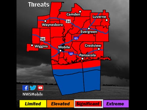

CRESTVIEW — Thunderstorms are forecast across Northwest Florida from Tuesday afternoon through Wednesday morning, according to the National Weather Service in Mobile.
The NWS expects tornadoes and wind gusts up to 80 mph, with hail reaching the size of golf balls.
Here are the latest storm-related updates:
●Okaloosa schools have re-opened and the storm has passed (8:28 a.m.)
●There is a report of a tree in the roadway on Highway 90 at Mount Olive Road.
●Standing water is on roadways for all of south end of Okaloosa County. You should avoid the roads, but if you are on them, please be careful.
●Flash flood warning in this coverage area until 12:30 a.m. Avoid flood areas.
●Florida Highway Patrol is closing I-10 from milemarker 17 to mm 43 due to a possible tornado. Stay home and off the roads.
●A tornado warning is in effect until 10 p.m.
●A tornado warning is in effect for Okaloosa and Santa Rosa counties. Take shelter immediately. (8:14 p.m.)
●Severe Thunderstorm Warning includes Fort Walton Beach, Wright area until 8:30 PM CST
●Community of Christ Church at 398 West First Avenue in Crestview will open a rain shelter at 6 p.m. Tuesday.
●Northwest Florida State College officials have canceled all classes, offices and campus activities. Campus activities will resume Wednesday morning.
●All Okaloosa County after-school activities after canceled.
●Crestview's Toastmasters International club meeting is canceled.
●The 6 p.m. meeting of the Okaloosa County Sheriff's Office Citizens Academy has been canceled.
If you have a weather update, please add it in the comments box below, and we'll add it to the story.
—
State Farm offers the following weather safety tips:
●Bring outdoor furniture, potted plants, grill, garbage cans inside. Anything that can be picked up by the wind and subsequently blown against your home should be secured ahead of time.
●Move your car into the garage or some other place where it will be sheltered. If you don't have a garage, move it to higher ground, in case of flooding.
●Moor boats securely. If your boat is ashore in a jack stand, strap the boat down when possible.
●Close window shutters or protective panels.
●Organize your important papers and store them off-site, in a bank safe-deposit box or some other secure location. Your mortgage, home and auto insurance policies, birth certificates, passports, and other important papers should be in a safe, dry location that you can access even if your home is damaged.
●Create a home inventory of your possessions to expedite insurance claims after the storm and keep it with your important papers off-site. It's much easier to file a claim with an existing inventory rather than trying to create one during the stressful post-storm period.
●Put together an emergency kit of bottled water, flashlights, crank- or battery-operated radio, non-spoilable food, extra clothing, sleeping bags and blankets.
After severe weather with damage:
●Avoid driving if possible. If you have to travel, turn around if the road is flooded or blocked by debris.
●Stay away from downed power lines. Anything touching the power line can carry a charge. Report the downed line and avoid the area.
●Clean up or rope off dangerous areas. Cover hail- or wind-damaged windows with tarps and plywood until an inspector can assess the damage.
●Use caution around debris. Sharp objects, broken glass or exposed nails may cause injuries that could lead to infection.
This article originally appeared on Crestview News Bulletin: CRESTVIEW AREA SEVERE WEATHER UPDATES